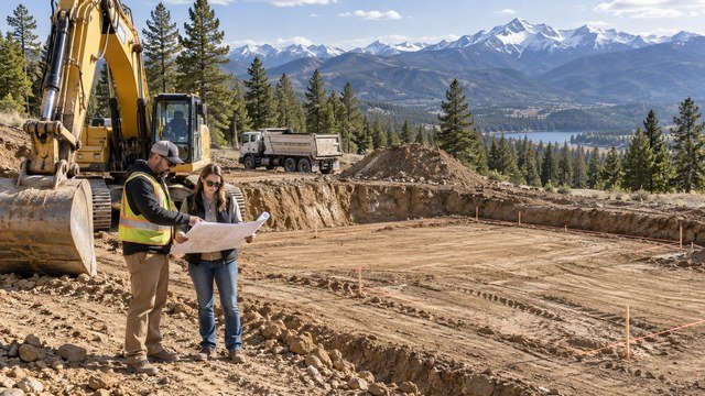
Good-looking ground can still hide expensive site problems
A rural Idaho parcel can look flat, dry, and easy to build on while the soil below the surface creates major foundation, grading, drainage, or retaining-wall costs.
Rock close to the surface, soft fill, expansive soil, shallow groundwater, steep slopes, old landslide deposits, or poorly compacted areas can all change how a home, shop, driveway, or septic system should be designed.
The best time to identify those issues is before the final homesite and construction budget are locked in.
Start with the difference between a soil map and a geotechnical investigation
A soil map is useful for early screening. It can show mapped soil types, drainage characteristics, slope, and other broad properties across a parcel.
A geotechnical investigation is site-specific. It evaluates actual subsurface conditions at or near the planned building area using field observations, borings, test pits, probes, laboratory testing, or other engineering methods.
Use mapping to identify questions, then use site-specific investigation when the project or local permitting process requires more certainty.
USDA Web Soil Survey is a strong first screening tool
The USDA Natural Resources Conservation Service operates Web Soil Survey, the federal government's online source for soil survey information.
The system can help land buyers review mapped soil units and explore suitability information for different land uses before committing to a specific homesite.
NRCS also notes that onsite investigation is still needed for some engineering and soil-quality decisions, so the map should not be treated as a substitute for field testing.
Do not confuse septic soil evaluation with structural geotechnical testing
A septic site evaluation is focused on wastewater disposal and soil conditions that affect a drainfield.
A geotechnical investigation focuses on the behavior of soil and rock under structures, fills, slopes, retaining walls, pavements, and other loads.
A parcel can pass septic review and still have difficult foundation or grading conditions, and the reverse can also be true.
Expansive soils can move foundations and flatwork
Some soils change volume as moisture conditions change.
That movement can affect foundations, slabs, patios, driveways, retaining walls, and buried utilities if the project is not designed for the site conditions.
If mapped geology, nearby construction history, cracking, or local experience suggests expansive soils, ask whether laboratory testing and a foundation recommendation are appropriate.
Collapsible or loose soils can create settlement risk
Loose native soil, undocumented fill, or certain moisture-sensitive deposits can compress after loading or wetting.
Settlement may be uneven, which is more damaging than uniform movement because different parts of the foundation can move by different amounts.
A geotechnical professional can evaluate whether removal, recompaction, deeper foundations, structural fill, or another approach is warranted.
Shallow bedrock can increase excavation cost
Rock near the surface is not always bad for bearing capacity, but it can make excavation more difficult and expensive.
House pads, basements, utility trenches, septic lines, well connections, and long driveways can require heavier equipment, hydraulic hammers, ripping, or blasting depending on the material and project.
Rock depth is one of the reasons a low-cost-looking homesite can become expensive after excavation begins.
Groundwater can change foundation, drainage, and excavation plans
Shallow groundwater or seasonal perched water can affect excavations, basement design, drainage, retaining walls, and construction scheduling.
A site that appears dry in late summer may behave very differently during snowmelt or a wet spring.
Ask about seasonal groundwater indicators, nearby wells, seepage, springs, wet areas, and whether the planned excavation depth is likely to encounter water.
Slope matters even when the building pad itself looks flat
The stability of the land above and below a homesite can matter as much as the pad itself.
Cuts at the uphill side, fills at the downhill side, retaining walls, driveway benches, and drainage changes can affect slope performance.
For hillside parcels, look beyond the footprint and evaluate the entire grading concept.
Idaho has real landslide and slope-stability hazards
The Idaho Geological Survey identifies landslides as an important geologic hazard in the state.
IGS explains that combinations of earth materials and steep terrain can increase slope-failure potential, and that both natural and human activities can contribute.
That makes mapped landslides, steep slopes, old scarps, hummocky ground, cracked pavement, leaning trees, and unusual drainage patterns worth investigating before construction.
Wildfire and heavy rain can compound slope problems
Idaho Geological Survey materials note that landslides and debris flows can be triggered by intense storms and that risk can increase after wildfire removes vegetation.
That is especially relevant for rural properties in steep or recently burned terrain.
The wildfire, drainage, and geotechnical parts of due diligence should be considered together instead of as separate issues.
Geologic maps can reveal issues a parcel listing will never mention
Idaho Geological Survey mapping can help identify the geologic framework beneath a property and screen for hazards such as landslides, faults, liquefaction potential, and other geologic conditions.
These maps are valuable for early due diligence, especially when the parcel sits on a steep hillside, canyon edge, river terrace, or unusual landform.
A map cannot replace site-specific engineering, but it can tell you when more investigation is justified.
Local jurisdictions can require geotechnical or engineering reports
Geotechnical requirements are not identical across Idaho because cities and counties administer local development standards.
For example, Ada County's hillside development process requires geologic investigation for proposed development in applicable hillside areas and calls for work by a registered professional geologist or professional engineer.
The exact trigger varies by jurisdiction, so ask the local planning and building departments what reports are required for the specific parcel.
State building codes still shape foundation design
Idaho has adopted statewide building codes, including the 2018 International Building Code and the Idaho Residential Code based on the 2018 International Residential Code with state amendments.
Those codes contain requirements that interact with soils, foundations, site preparation, drainage, and structural design.
The local building official or applicable state program can explain how those requirements are administered for the project location.
A geotechnical report can guide foundation recommendations
A typical geotechnical report may provide recommendations for allowable bearing, foundation type, footing depth, slab support, moisture conditioning, structural fill, drainage, and excavation.
On difficult sites it may also address settlement, expansive soil, frost, groundwater, slope stability, retaining walls, or seismic considerations.
The engineer designing the structure uses those recommendations as part of the foundation and site design.
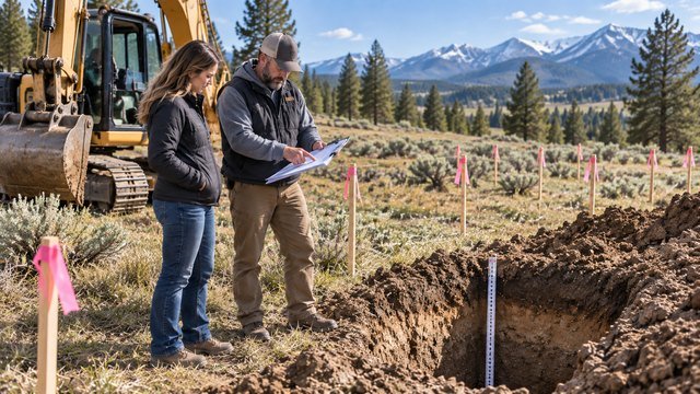
Test pits can be useful for rural site planning
Test pits can expose shallow soil and rock conditions over a wider area than a small-diameter boring.
They are often useful for observing fill, topsoil depth, rock, groundwater seepage, soil layering, and excavation conditions.
The right investigation method depends on the site, structure, and questions that need to be answered.
Borings provide deeper information
Drilled borings can evaluate subsurface conditions below the depth practical for ordinary test pits.
They may be used to collect samples, identify soil and rock layers, and support engineering estimates of settlement, bearing, or slope behavior.
A geotechnical professional should determine the number, depth, and location of borings based on the project.
The future house location should be chosen before testing
Testing is most useful when it is performed where the actual structure, retaining wall, or major fill is expected to go.
If the homesite moves hundreds of feet after the investigation, the original data may not represent the new location.
Use the survey, zoning setbacks, septic layout, driveway, utilities, and topography to narrow the building envelope before spending heavily on site-specific testing.
Large shops and barndominiums deserve the same soil attention
A large post-frame, steel, or barndominium structure can place substantial loads on isolated footings, continuous foundations, or slabs.
Long clear spans, tall walls, heavy equipment, mezzanines, and attached living areas can make foundation performance especially important.
Do not assume that a metal building eliminates the need for soil information.
Retaining walls can trigger additional engineering
Retaining-wall performance depends on the soil behind the wall, groundwater, drainage, slope, wall height, and surcharge loads.
A wall supporting a driveway, building pad, or steep cut can become a major engineered element rather than a simple landscaping feature.
Use the geotechnical findings together with structural design before finalizing wall height and placement.
Fill is one of the biggest rural-site unknowns
Old rural properties sometimes contain undocumented fill placed for driveways, ponds, barn pads, burn areas, previous structures, or informal grading.
If the future house sits partly on native soil and partly on uncontrolled fill, uneven settlement can become a concern.
Ask whether suspicious fill should be removed, tested, recompacted, or avoided.
Compaction testing matters when building a pad
When a building pad is created with imported or reworked soil, proper placement and compaction become part of the foundation system.
Engineered fill is commonly placed in controlled lifts and tested to verify that it meets the project requirements.
Skipping that process can save money during dirt work and create far more expensive problems later.
Drainage should be designed with the soil, not after the house
Soil permeability and slope influence how quickly water infiltrates, ponds, or moves across the site.
Roof runoff, driveway drainage, snowmelt, irrigation, and uphill flow should be directed so they do not saturate foundations, fills, retaining walls, or unstable slopes.
The grading plan and drainage plan should work with the geotechnical recommendations.
The driveway can have different soil problems than the homesite
A long rural driveway may cross soft ground, drainage swales, steep grades, shallow rock, or wet areas even when the house pad is excellent.
Subgrade conditions affect excavation depth, geotextile use, base thickness, culverts, and long-term maintenance.
For expensive access roads, include the driveway corridor in the site investigation and earthwork planning.
A survey and geotechnical report solve different problems
The land survey establishes where boundaries, easements, monuments, and improvements are located.
The geotechnical investigation explains how soil and rock at the proposed development area are likely to behave.
Both are important on complicated rural parcels because a legally buildable area can still be physically difficult to develop.
Geotechnical findings can change the real cost of the land
A lower-priced parcel may require deeper foundations, engineered fill, extensive rock excavation, retaining walls, drainage improvements, or slope stabilization.
A more expensive parcel with straightforward soils and grading may cost less once the complete build-ready budget is considered.
Compare properties using total site-development cost instead of purchase price alone.
Ask for existing reports before ordering new work
The seller, prior owner, subdivision developer, neighboring builder, or local jurisdiction may already have geotechnical, geologic, grading, drainage, or well information for the area.
Existing reports can provide useful context, although they may not be sufficient for a new project or exact homesite.
Give any prior reports to the professional evaluating the property so they can decide what information remains useful.
Warning signs that justify more investigation
Not every rural parcel needs the same level of geotechnical work, but certain site conditions should raise more questions.
- Steep or terraced slopes
- Visible scarps, cracks, hummocky ground, or leaning trees
- Recent wildfire on or above the property
- Wet ground, springs, seeps, or seasonal saturation
- Large cuts or fills
- Unknown or undocumented fill
- Rock outcrops near the planned house or utility routes
- Neighboring homes with settlement or foundation problems
- A planned basement on sloping ground
- Tall retaining walls
- A long driveway across variable terrain
- Mapped landslide or geologic hazard areas
Questions to ask a geotechnical professional
A focused conversation can help define the right scope before you authorize testing.
- What site conditions are you most concerned about?
- Do you recommend test pits, borings, laboratory tests, or a combination?
- How many exploration points are appropriate for the planned structures?
- Should the driveway, retaining walls, or shop be investigated too?
- Do you see evidence of undocumented fill?
- Is groundwater likely to affect excavation or foundations?
- Are expansive or collapsible soils a concern?
- Do slopes require stability analysis?
- What foundation options are likely to work here?
- What site grading or drainage measures do you recommend?
- What information will the structural engineer need from your report?
Questions to ask the county or city before closing
Local staff can tell you whether geotechnical or geologic review is required before a permit can be issued.
- Does this parcel fall within a hillside, landslide, or geologic-hazard overlay?
- Is a geotechnical report required for a building permit?
- Is a separate geologic report required?
- Are there slope thresholds that trigger additional review?
- Are engineered retaining walls or grading plans required?
- Are there special drainage or erosion-control requirements?
- Who is authorized to prepare the required report?
- Can I review reports from nearby developments?
- Should the report be completed before the building permit application?
A practical soil and geotechnical due-diligence checklist
Use this sequence before committing to a final building plan.
- Review USDA Web Soil Survey
- Review Idaho Geological Survey maps and hazard information
- Walk the site during due diligence
- Look for slope movement, wet areas, rock, and fill
- Confirm the proposed homesite with a survey or reliable site plan
- Coordinate with septic, well, driveway, and utility layouts
- Ask the local jurisdiction about geotechnical requirements
- Collect any existing geotechnical or subdivision reports
- Hire the appropriate geotechnical professional when needed
- Complete testing at the actual planned development area
- Use the report to refine foundation, grading, drainage, and retaining-wall budgets
- Do not finalize the construction price until major soil risks are understood
Connect soil due diligence to the full AcreageReady plan
Soils are only one part of making Idaho acreage build-ready.
A complete plan also needs zoning confirmation, property boundaries, access, septic, water, power, flood review, wildfire planning, grading, excavation, and realistic contractor pricing.
The strongest rural-land purchase is the one where all of those systems can work together on the same buildable portion of the parcel.
Keep researching
Acreage Planning resources
Due diligence, development sequencing, utilities, access, and the decisions that shape a rural property project.
Sources & methodology
Where this information comes from
Cost figures are planning references rather than contractor quotes. Permitting, system-selection, and location-specific guidance should be verified with the appropriate local authority or qualified professional. AcreageReady uses source-backed, AI-assisted editorial workflows and remains responsible for the material it publishes. Read how we research, edit, and correct guides.
- USDA NRCS: Web Soil Survey
- Idaho Geological Survey: Geologic Hazards
- Idaho Geological Survey: Landslides
- Idaho Geological Survey: Geologic Mapping
- Idaho DOPL: Idaho Adopted Codes
- Ada County: Hillside Development Application
- AcreageReady: Idaho Zoning & Building Permits
- AcreageReady: Idaho Land Surveys & Property Lines
- AcreageReady: How Much Does Excavation Cost in Idaho?
- AcreageReady: How Much Does It Cost to Grade Land for a House in Idaho?
- AcreageReady: How Much Does a Retaining Wall Cost in Idaho?
Common questions
Frequently asked questions
Do I always need a geotechnical report to build a house in Idaho?
Not necessarily. Requirements vary by jurisdiction, site conditions, slope, project type, and building department. Ask the city or county with jurisdiction over the parcel whether a report is required.
Is USDA Web Soil Survey enough to design a foundation?
No. Web Soil Survey is useful for screening and planning, but NRCS notes that onsite investigation is needed for some engineering applications. Foundation design should rely on the site-specific information required by the project and building authority.
Is a septic test the same as a geotechnical test?
No. Septic evaluations focus on wastewater disposal conditions. Geotechnical investigations focus on soil and rock behavior for foundations, fills, slopes, retaining walls, and other structural or earthwork needs.
When should I test the soil on rural Idaho land?
Testing is most useful after the likely homesite and major improvements are identified but before final foundation design, grading contracts, or construction pricing are locked in.
Can rocky ground be expensive even if it is strong?
Yes. Strong rock may support structures well but can increase excavation, trenching, utility, basement, and septic construction costs.
What are signs of possible slope instability?
Possible warning signs include scarps, cracks, hummocky terrain, leaning trees, distorted fences, springs, saturated ground, damaged pavement, and evidence of older landslides. A qualified professional should evaluate suspected instability.
Can geotechnical problems make a parcel unbuildable?
Sometimes. More often they change the design, location, engineering, or cost of the project. Severe slope, groundwater, settlement, or geologic hazards can make development impractical even when zoning allows a home.
Should I investigate the driveway too?
For long or steep rural driveways, yes. Soft subgrade, drainage crossings, shallow rock, and steep slopes can materially affect driveway cost and maintenance.
Ready to talk with a local professional?
Share your location and project details so AcreageReady can identify relevant providers as the network grows.
Get a free quote